
 Česky
Česky Deutsch


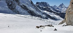
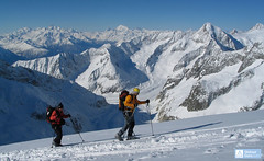
Monte Rosa Hütte is a state-of-the-art, self-sufficient hut that was built a little higher than the original hut. The MRH is reachable from Zermatt by the Gornergletscher glacier, after a ski tour across the Breithorn and downhill on the Schwärzegletscher, and the fastest access is from the Rotenboden station in the Gornergrat railway. Starting point for ski tour to Nordend, Dufourspitze in Monte Rosa, Signallkuppe, Pollux, Castor and Cima Jazzi.
Tours starting from hut
Ski tours around Hut Monte Rosa Hütte
-
Signalkuppe / Punta Gnifetti 4554 m
Monte Rosa Hütte Walliser Alpen / Alpes valaisannes Switzerland
- Length of ascent8,5 km
- ascent1680 m
- duration9-10,5 h
- Fitness difficulty ♦♦♦◊
- Technical difficulty ♦♦♦◊
Signalkuppe / Punta Gnifetti is the highest peak in the Alps that can be climbed on skis. At the top, you can sleep in the winter room of the highest mountain hut in the Alps - Capanna Margherita (CAI). From the top is a fantastic view of the Italian part of the Alps. In the first half of this long ski tour, watch out for numerous crevasses. The rest of the ski tour over the glacier Grenzgletscher is technically easy and there is no steep passage along the entire route. This ski mountain tour is practically impossible during low-snow winters - inquire at the Monte Rosa Hut.

-

Dufourspitze / Punta Dufour - Monte Rosa 4634 m
Monte Rosa Hütte Walliser Alpen / Alpes valaisannes Switzerland
- Length of ascent6,5 km
- ascent1760 m
- duration9-11,5 h
- Fitness difficulty ♦♦♦♦
- Technical difficulty ♦♦♦♦
Dufourspitze / Punta Dufour je nejvyšším vrcholem Švýcarska v masivu Monte Rosa. Skialpinistická túra na vrchol je až do výšky 4000 m shodná s výstupem na Norden. Trasa na Dufourspitze se pak stáčí jižním směrem na ledovec Satteltolle na odtud bez lyží po hřebeni na vrchol. Původní trasa výstupu ze sedla Silbersattel je od roku 2019 nelezitelná, fixní lana byla odstraněna.
-

Breithorn - Zermatt 4164 m
Monte Rosa Hütte Walliser Alpen / Alpes valaisannes Switzerland
- Length of ascent3 km
- ascent440 m
- duration3-4 h
- Fitness difficulty ♦♦♦◊
- Technical difficulty ♦♦♦◊
Breithorn can be rated as the lightest 4000 in the Alps. In any case, thanks to the support of the Klein Matterhorn cable car, which transports ski mountaineers up to 3880 m. From the cable car station (beautiful viewpoint) to the glacier plain below the summit, which can be often reached on skis. In good conditions, it is worthwhile to continue to the Schwarztor saddle and drive descent back to Zermatt. The second variant of the freeride is the descent from the Unterer Theodulgletscher. This descent is simply great up to Seehöre 2400.
-

Nordend - Monte Rosa 4609 m
Monte Rosa Hütte Walliser Alpen / Alpes valaisannes Switzerland
- Length of ascent7 km
- ascent1745 m
- duration10-12,5 h
- Fitness difficulty ♦♦♦♦
- Technical difficulty ♦♦♦♦
Nordend is a very challenging glacier ski tour to an important summit in the Monte Rosa massif. The biggest problem is the huge crevasses, due to which the ascent and descent route has to be adjusted. Relevant information about this is available in the Monte Rosa Hut. Only creviasses make difficult the ascent to the saddle Silbersattel, further up the ascent without skis (crampons + ice axe) bends along a relatively exposed slope to the summit. The descent is fantastic, but watch out for cracks again. Simply put, challenging ski tour!
- Country
- Switzerland
- Montains
- Walliser Alpen / Alpes valaisannes
- Open (winter)
- March-mid May
- Beds
- 120
- Winterraum
- 12
- Shortening of access (cableway, lift, taxi, snowcat...)
- yes, by train from Zermatt to Rotenboden
- Luggage transport
- no
- Card Pay
- yes
- Shower
- yes
- Wifi
- no
- UTM / CH1903 x ("longitude" E/W)
- 629148
- UTM / CH1903 y ("latitude" N/S)
- 89553
- GPX access to hut (waipoints, track)
- MtRosaHut_all_access.gpx
- GPX access to hut (track only)
- MtRosaHut_all_access_TRK.gpx
- Map
- Mischabel 284 S, Swisstopo 1:50000 Zermatt 1348, Swisstopo 1:25000
- Guides
- Walliser Alpen Ost / SAC, deutsch Die klassischen Skitouren (SAC, deutsch) Les classiques de randonnée à ski (SAC, francais) Walliser Alpen (Rother, deutsch)
- Phone (hut)
- +41 (0)27 967 21 15
- Phone (valley)
- -
- Cell phone
- +41 79 416 35 06
- Mobile Signal
- yes
- Web
- monterosahuette.ch
- info@monterosahuette.ch
- Owner of hut
- SAC Monte Rosa
- Hütte Monte Rosa
- Reservation
- online form
- Online reservation
- alpsonline.org
- Start Point
- Klein Matterhorn
- UTM / CH1903 x ("longitude" E/W)
- 622528
- UTM / CH1903 y ("latitude" N/S)
- 87348
- Altitude
- 3800 m
- Ascent (height difference)
- 400 m
- Time of Access
- 4-5 h
- Shortening lift
- yes, by cablecar form Zermatt - https://www.matterhornparadise.ch
- Start Point
- Rotenboden
- UTM / CH1903 x ("longitude" E/W)
- 625313
- UTM / CH1903 y ("latitude" N/S)
- 92602
- Altitude
- 2820 m
- Ascent (height difference)
- 400 m
- Time of Access
- 2-3 h
- Shortening lift
- by train from Zermatt (0,5 h) - https://www.gornergratbahn.ch
- Start Point
- Zermatt - Zenstecken
- UTM / CH1903 x ("longitude" E/W)
- 623481
- UTM / CH1903 y ("latitude" N/S)
- 96025
- Altitude
- 1620 m
- Ascent (height difference)
- 1300 m
- Time of Access
- 6-7 h
- Shortening lift
- no
- Avalanche danger
- SLF - Institut für Schnee- und Lawinenforschung
- Weather
- Monte Rosa Hütte / meteoblue.com Gornergrat 3130m / meteocentrale.ch Klein Matterhorn 3880m / mountain-forecast.com Gornergrat 3130m / mountain-forecast.com Ludwigshöhe 4344m / mountain-forecast.com Breithorn 4160m / mountain-forecast.com Lyskamm 4527m / mountain-forecast.com Schweiz / meteo.ch Schweiz TV - animation Bergwetter / alpenverein.at Zermatt / kachelmannwetter.com
- Snow report
- Zermatt / snow-forecast.com Zermatt / onthesnow.com Zermatt / http://snow.myswitzerland.com/
- Webcams
- Zermatt - Gornergrat Zermatt - Bahnhof Zermatt - 29 webcams
- Region
- Zermatt.ch Wallis.ch
- Public traffic
- SBB Railway Postauto.ch - bus
- Skiresort nearby
- Zermatt, matterhornparadise.ch
- Other links
- Swiss Tourism
hut Monte Rosa Hütte - Reviews
There are no reviews in this section yet. Click the Add Review button to add first review.
Best ski tours in mountains Walliser Alpen / Alpes valaisannes, Switzerland
-

La Luette 3547 m
Cabane des Dix Walliser Alpen / Alpes valaisannes Switzerland
- Length of ascent3 km
- ascent710 m
- duration1,5-3 h
- Fitness difficulty ♦♦◊◊
- Technical difficulty ♦♦◊◊
La Luette je vděčná túra z chaty Cabane Dix. Po mírném svahu na ledovec Glacier de la Luette a v závěru po hřebenu na vrchol. Pouhých 500 výškových metrů od chaty může být lákadlem pro odpolední túru poté, když dorazíte brzo na chatu Dix.
-

Tour du Ciel - day 2 3404 m
Schönbielhütte Walliser Alpen / Alpes valaisannes Switzerland
- Length of ascent5 km
- ascent1190 m
- duration5-7 h
- Fitness difficulty ♦♦♦◊
- Technical difficulty ♦♦♦◊
Tour du Ciel (known as the reverse direction of the Haute Route Impériale) begins with the first real stage from the Schönbiel Hut, featuring a descent along the edge of the moraine. This is followed by a long, steep climb over glacier seracs, ideally tackled in the early morning. The subsequent ascent over the Hohlwäng Glacier to the Col Durand (3404 m) is then straightforward. An alternative is to turn right before the pass and climb Mont Durand. From the pass, descend over the Glacier Durand, followed by a short climb to the Cabane Mountet.
-

Tour du Ciel - day 3 3649 m
Cabane du Mountet Walliser Alpen / Alpes valaisannes Switzerland
- Length of ascent10,5 km
- ascent2420 m
- duration10-12 h
- Fitness difficulty ♦♦♦♦
- Technical difficulty ♦♦♦♦
A very long and demanding, royal stage of this Haute Route. In my opinion, the most impressive stage of all multi-day Alpine crossings. Due to the elevation gain and time required, it’s worth considering splitting the stage into two days with an overnight stay in Zinal. The long, exposed ridge to the summit requires rope protection depending on conditions. The descent is fantastically long, but caution is needed – there are large crevasses. This ski tour is only recommended in stable weather; in poor conditions, it’s advisable to bypass the Blanc de Moming via the Glacier de Zinal and ascend directly to the Cabane de Tracuit.
Best ski tours in Switzerland by skitour.guru
-
Grosser Aletschhorn 4189 m
Oberaletschhütte Berner Alpen / Alpes bernoises Switzerland
- Length of ascent7 km
- ascent1750 m
- duration7-9 h
- Fitness difficulty ♦♦♦♦
- Technical difficulty ♦♦♦◊
Grosser Aletschhorn is lonely 4000 in the middle of the Berner Alps in Switzerland over the Oberaletschgletscher and the hut of the same name. From the top views of the Wallis Alps, including the Matterhorn.
-

Piz Buin SE (Tuoihütte) 3312 m
Tuoi Chamonna / Tuoihütte Silvretta Switzerland
- Length of ascent5,5 km
- ascent1170 m
- duration5,5-7 h
- Fitness difficulty ♦♦♦◊
- Technical difficulty ♦♦♦◊
Piz Buin ze švýcarské strany je zajímavější túra než ze strany rakouské. výstup v závěrečné části je stejný. Pod stěnu vede trasa přes sedla Plan Mezdi a Fuorcla dal Cunfin. Za stabilní sněhové pokrývky je alternativou sjezd žlabem Buinlücke.
-

Äbeni Flue - Ebnerfluh 3962 m
Hollandiahütte (Lötschenhütte) Berner Alpen / Alpes bernoises Switzerland
- Length of ascent4,5 km
- ascent800 m
- duration3,5-5 h
- Fitness difficulty ♦♦◊◊
- Technical difficulty ♦♦◊◊
Relatively easy glacier ski tour to the most popular summit of the Hollandia hut. The glacier is not too cracked and the ascent path is gradually gaining altitude. At the end, ridge is waiting between the secondary and main summits. With good visibility it is a ski tour without complications.