
 Česky
Česky Deutsch


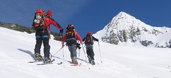


Velkolepá a náročná túra na vrchol v monumentální horské krajině mezi ledovci. Z chaty Chanrion po trase do sedla Portons. Včas odboč doleva na ledovec Brenay. Klíčem k úspěchu je trefit kanál, kterým se vystoupá na svah Ruinette a poměrně snadno se pokračuje do sedla pod vrcholovou pyramidu. Tady je skidepot a dále v mačkách a s cepínem. Sjezd po trase výstupu.
Peak
- Country
- Switzerland
- Montains
- Walliser Alpen / Alpes valaisannes
- Tags
- Alpes valaisannes Haute Route Chamonix-Zermatt Mauvoisin Schweiz Switzerland Val de Bagnes Valais Wallis
- Hut
- Cabane Chanrion
- UTM / CH1903 x ("longitude" E/W)
- 597028
- UTM / CH1903 y ("latitude" N/S)
- 91948
Start point
- Start Point
- Cabane Chanrion
- Altitude
- 2462 m
- UTM / CH1903 x ("longitude" E/W)
- 595520
- UTM / CH1903 y ("latitude" N/S)
- 87510
Conditions
- Avalanche danger
- www.slf.ch
- Weather
- SRF Meteo Meteoschweiz snow-forecast.com Pointe d'Otemma, mountain-forecast.com Mont Avril, mountain-forecast.com La Ruinette, mountain-forecast.com Lac Mauvoisin - meteoblue.com Mont Oulié, mountain-forecast.com Grand Teve, Meteoblue.com Lac Mauvoisin - yr.no
- Snow report
- snow-forecast.com - Verbier bergfex.ch - Verbier onthesnow.com skiresort.info snow.myswitzerland.com/
- Webcams
- Mont Fort 3300 m (Verbier) Lourtier - Val Bagnes
Ski tour map on La Ruinette


 bivakovací nouzová chata
  cepín a mačky potřeba
 exponovaný, obtížný terén
 horská chata
 hôtel, penzion
 lanovka, vlek
 lavinové nebezpečí, svah > 30°
 ledovcové trhliny
 lehká túra
 mimořádně obtížná túra
 mírně obtížná túra
 obtížná túra
 parkoviště
 přístup k chatě
 restaurace
 sedlo
sedlo sjezd
sjezd skidepo
 vrchol
 výstup
 začátek ledovce
- bivouac, winter room
- crampons & ice axe necessary
- exposed, difficulty terrain
- mountain hut, refuge
- hotel, pension
- cableway, skilift
- avalanche danger, slope > 30°
- glacier cracks
- little difficult tour
- extremely difficult tour
- rather difficult tour
- difficult tour
- parking
- hut acces
- restaurant
- col, pass, saddle
- descent
- skidepot
- peak, summit
- ascent
- glacier beginning
- biwak, winterraum
- steigeisen & pickel erforderlich
- ausgesetzt, schwierige gelände
- berghütte
- hotel, pension
- seilbahn, skilift
- lawinengefahr, hangneigung > 30°
- gletscherspalten
- wenig schwierige tour
- äusserst schwierige tour
- ziemlich schwierige tour
- schwierige tour
- parkplatz
- zugang zur hütte
- restaurant
- sattel, joch, pass
- abfahrt
- skidepot
- gipfel
- aufsieg
- gletscher anfang
- bivacco, locale invernale
- ramponi & piccozza necessari
- esposto, terreno difficolt?
- rifugio, capanna
- alberghi, pensione
- funivia, seggiovia
- pericolo di valanghe, pendenza > 30°
- crepe glacier
- tour piccolo difficile
- tour estremamente difficile
- tour piuttosto difficile
- escursioni difficili
- parcheggio
- accesso capanna
- ristorante
- col, sella, passo, forcella
- discesa
- sci deposito
- picco, vertice, piz
- salita
- inizio ghiacciaio
- bivouac, local d'hiver
- crampons & piolet nécessaire
- exposée, difficulté du terrain
- cabane de montagne, refuge
- hôtel, pension
- téléphérique, téléski
- danger d'avalanche, pente > 30°
- crevasse du glacier
- peu difficile tour
- extr?mement difficile tournée
- assez difficile tour
- difficile tournée
- parking
- acces cabane
- restaurant
- col, selle
- descente
- skis dépôt
- pic, sommet
- ascension
- début glacier
- < 20°
- 20° - 25°
- 25° - 30°
- 30° - 35°
- 35° - 40°
- > 40°
Current weather conditions in the tour area
Planning of ski tour
- Fitness difficulty
-
- ♦♦♦♦
- Technical difficulty
-
- ♦♦♦♦
- best time for this tour
- April-May
- Glacier
- Yes
- Map
- Arolla 283 S, Swisstopo 1:50000 Chanrion 1346, Swisstopo 1:25000 Matterhorn 1347, Swisstopo 1:25000
- Guides
- Ski de randonnée Bas-Valais Die klassischen Skitouren (SAC, deutsch) Les classiques de randonnée à ski (SAC, francais) Walliser Alpen (Rother, deutsch)
About Ski tour
- Time difficulty
- Ascent (height difference)
- 1490 m
- Lenght of ascent
- 8 km
- Descent (height difference)
- 1490 m
- Total Lenght of tour
- 16 km
- Total time of the tour
- 7-9,5 h
- Elevation Range
- 2465 - 3875 m
- Principal Aspect
- SW, NW, SE S-south, N-north, W-west, E-east
Download
- GPX (track only)
- La Ruinette_Chanrionhut_TRK.gpx best for display on a detailed topographical map (mapy.cz) or in apps for smartphones (Locus, Garmin Connect, etc.)
- GPX (waipoints, track)
- Ruinette_Chanrion-Hut_skitour.gpx great for uploading in GPS device
- KML (with POI)
- LaRuinette_ChanrionHut_Skitour Guru.kml for viewing in the Google Earth 3D map application, which you can install on your PC
Video of tour on La Ruinette
tour La Ruinette - Reviews
There are no reviews in this section yet. Click the Add Review button to add first review.
Ski tours around Hut Cabane Chanrion , in mountains Walliser Alpen / Alpes valaisannes, Switzerland

Best ski tours in Walliser Alpen / Alpes valaisannes by skitour.guru
-

Tour du Ciel - day 4 4153 m
Cabane Tracuit Walliser Alpen / Alpes valaisannes Switzerland
- Length of ascent6 km
- ascent1150 m
- duration5,5-7,5 h
- Fitness difficulty ♦♦♦◊
- Technical difficulty ♦♦♦◊
The stage begins at the Cabane Tracuit with an ascent of the 4,000-meter peak Bishorn, which is considered relatively easy. After skiing back down to the Tracuit hut, the route continues with a descent over the Turtmanngletscher glacier. A subsequent climb over the Brunegggletscher glacier leads into a rocky corridor, which marks the beginning of the descent to the Turtmannhütte.

-

Bishorn 4153 m
Cabane Tracuit Walliser Alpen / Alpes valaisannes Switzerland
- Length of ascent4,5 km
- ascent950 m
- duration5-6,5 h
- Fitness difficulty ♦♦♦◊
- Technical difficulty ♦♦◊◊
Bishorn seems to be a relatively light 4000, but looks are deceptive. If you include the approach to Cabane Tracuit from Zinal in the ascent, it is quite a long ski tour. From the hut the ascent line leads slightly up the glacier Turtmanngletscher. Directly below the peak on the plateau you have to swap skis for crampons and comfortably climb to the panoramic summit - one of the best in all of Valais. Driving down the northern slope is usually a fantastic enjoyment, the risk of glacier cracks is minimal.
-

Fenetre Ferret - H.R. Grande Lui, Day 3 2698 m
La Fouly Walliser Alpen / Alpes valaisannes Switzerland
- Length of ascent11 km
- ascent1330 m
- duration5-7 h
- Fitness difficulty ♦♦♦◊
- Technical difficulty ♦♦◊◊
The Haute Route Grande Lui variant from Chamonix to Zermatt, also known as the "Haute Route Pure", leads from La Fouly to the Grand Saint Bernard Pass. Overnight accommodation is provided in the hospice of the same name, under conditions similar to those in a mountain hut. The traverse of the slope below the Ferret lakes is particularly prone to avalanches.