
 Česky
Česky Deutsch


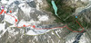


The fourth stage of the Haute Route from Chamonix to Zermatt is one of the most beautiful mountain experiences. First ascent from Cabane Valsorey to the Plateau Couloir Sattel, for the most part an ascent with crampons is necessary. This is followed by a long descent over the Col Sonadon saddle along the Glacier du Mont Durand and at the end an easy ascent to the hut Cabane Chanrion.
Peak
- Country
- Switzerland
- Montains
- Walliser Alpen / Alpes valaisannes
- Tags
- Grand Combin Haute Route Chamonix-Zermatt Pays du Saint Bernard Schweiz Switzerland Valais Wallis
- Hut
- Cabane Valsorey
- UTM / CH1903 x ("longitude" E/W)
- 588085
- UTM / CH1903 y ("latitude" N/S)
- 86881
Start point
- Start Point
- Cabane Valsorey
- Altitude
- 3033 m
- UTM / CH1903 x ("longitude" E/W)
- 587060
- UTM / CH1903 y ("latitude" N/S)
- 86544
Conditions
- Avalanche danger
- www.slf.ch
- Weather
- SRF Meteo Meteoschweiz Combin Meitin, mountain-forecast.com Cab. Valsorey, Meteoblue.com Plateau Couloir, Meteoblue.com Gr. Combin Valsorey, mountain-forecast.com Gr. Tete de By, mountain-forecast.com Bourg St.-Pierre, yr.no Bourg St.-Pierre, meteoblue.com
- Snow report
- bergfex.ch, Liddes - Vichères
- Webcams
- Grand St. Bernard Tunnel
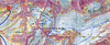
Ski tour map on Plateau Couloir, Day4 H.R.Chamonix-Zermatt


 bivakovací nouzová chata
  cepín a mačky potřeba
 exponovaný, obtížný terén
 horská chata
 hôtel, penzion
 lanovka, vlek
 lavinové nebezpečí, svah > 30°
 ledovcové trhliny
 lehká túra
 mimořádně obtížná túra
 mírně obtížná túra
 obtížná túra
 parkoviště
 přístup k chatě
 restaurace
 sedlo
sedlo sjezd
sjezd skidepo
 vrchol
 výstup
 začátek ledovce
- bivouac, winter room
- crampons & ice axe necessary
- exposed, difficulty terrain
- mountain hut, refuge
- hotel, pension
- cableway, skilift
- avalanche danger, slope > 30°
- glacier cracks
- little difficult tour
- extremely difficult tour
- rather difficult tour
- difficult tour
- parking
- hut acces
- restaurant
- col, pass, saddle
- descent
- skidepot
- peak, summit
- ascent
- glacier beginning
- biwak, winterraum
- steigeisen & pickel erforderlich
- ausgesetzt, schwierige gelände
- berghütte
- hotel, pension
- seilbahn, skilift
- lawinengefahr, hangneigung > 30°
- gletscherspalten
- wenig schwierige tour
- äusserst schwierige tour
- ziemlich schwierige tour
- schwierige tour
- parkplatz
- zugang zur hütte
- restaurant
- sattel, joch, pass
- abfahrt
- skidepot
- gipfel
- aufsieg
- gletscher anfang
- bivacco, locale invernale
- ramponi & piccozza necessari
- esposto, terreno difficolt?
- rifugio, capanna
- alberghi, pensione
- funivia, seggiovia
- pericolo di valanghe, pendenza > 30°
- crepe glacier
- tour piccolo difficile
- tour estremamente difficile
- tour piuttosto difficile
- escursioni difficili
- parcheggio
- accesso capanna
- ristorante
- col, sella, passo, forcella
- discesa
- sci deposito
- picco, vertice, piz
- salita
- inizio ghiacciaio
- bivouac, local d'hiver
- crampons & piolet nécessaire
- exposée, difficulté du terrain
- cabane de montagne, refuge
- hôtel, pension
- téléphérique, téléski
- danger d'avalanche, pente > 30°
- crevasse du glacier
- peu difficile tour
- extr?mement difficile tournée
- assez difficile tour
- difficile tournée
- parking
- acces cabane
- restaurant
- col, selle
- descente
- skis dépôt
- pic, sommet
- ascension
- début glacier
- < 20°
- 20° - 25°
- 25° - 30°
- 30° - 35°
- 35° - 40°
- > 40°
Current weather conditions in the tour area
Planning of ski tour
- Fitness difficulty
-
- ♦♦♦◊
- Technical difficulty
-
- ♦♦♦◊
- best time for this tour
- April-mid May
- Glacier
- Yes
- Map
- Arolla 283 S, Swisstopo 1:50000 Chanrion 1346, Swisstopo 1:25000 Mont Vélan 1366, Swisstopo 1:25000 Orsiéres 1345, Swisstopo 1:25000
- Guides
- Ski de randonnée Bas-Valais Die klassischen Skitouren (SAC, deutsch) Les classiques de randonnée à ski (SAC, francais) Walliser Alpen (Rother, deutsch)
About Ski tour
- Time difficulty
- Ascent (height difference)
- 1085 m
- Lenght of ascent
- 3,5 km
- Descent (height difference)
- 1650 m
- Total Lenght of tour
- 13,5 km
- Total time of the tour
- 6-8 h
- Elevation Range
- 2255 - 3640 m
- Principal Aspect
- SW, SE, S, E S-south, N-north, W-west, E-east
Download
- GPX (track only)
- HR4d ValsoreyHut_Plateau-Couloir_Chanrion_TRK.gpx best for display on a detailed topographical map (mapy.cz) or in apps for smartphones (Locus, Garmin Connect, etc.)
- GPX (waipoints, track)
- HR4d_ValsoreyH_ChanrionH_skitour.gpx great for uploading in GPS device
- KML (with POI)
- HRC ValsoreyHut-ChanrionHut_HauteRouteChamxZer_4day.kml for viewing in the Google Earth 3D map application, which you can install on your PC
Video of tour on Plateau Couloir, Day4 H.R.Chamonix-Zermatt
tour Plateau Couloir, Day4 H.R.Chamonix-Zermatt - Reviews
There are no reviews in this section yet. Click the Add Review button to add first review.
Best ski tours in Walliser Alpen / Alpes valaisannes by skitour.guru
-

Breithorn - Zermatt 4164 m
Monte Rosa Hütte Walliser Alpen / Alpes valaisannes Switzerland
- Length of ascent3 km
- ascent440 m
- duration3-4 h
- Fitness difficulty ♦♦♦◊
- Technical difficulty ♦♦♦◊
Breithorn can be rated as the lightest 4000 in the Alps. In any case, thanks to the support of the Klein Matterhorn cable car, which transports ski mountaineers up to 3880 m. From the cable car station (beautiful viewpoint) to the glacier plain below the summit, which can be often reached on skis. In good conditions, it is worthwhile to continue to the Schwarztor saddle and drive descent back to Zermatt. The second variant of the freeride is the descent from the Unterer Theodulgletscher. This descent is simply great up to Seehöre 2400.

-

Pigne d´Arolla 3790 m
Cabane des Dix Walliser Alpen / Alpes valaisannes Switzerland
- Length of ascent6 km
- ascent1000 m
- duration5-7,5 h
- Fitness difficulty ♦♦◊◊
- Technical difficulty ♦♦♦◊
Pigne d´Arolla is a very popular and easily accessible viewpoint. The ski tour to the summit leads from the three mountain huts - Cabane Dix, Cabane Vignettes and Cabane Chanrion. The route from Dix goes around the glacial seracs to the saddle Col de la Serpentine and the summit can be reached on skis. A worthwhile summit on the Haute Routes to Zermatt.
-

Tour du Ciel - day 2 3404 m
Schönbielhütte Walliser Alpen / Alpes valaisannes Switzerland
- Length of ascent5 km
- ascent1190 m
- duration5-7 h
- Fitness difficulty ♦♦♦◊
- Technical difficulty ♦♦♦◊
Tour du Ciel (known as the reverse direction of the Haute Route Impériale) begins with the first real stage from the Schönbiel Hut, featuring a descent along the edge of the moraine. This is followed by a long, steep climb over glacier seracs, ideally tackled in the early morning. The subsequent ascent over the Hohlwäng Glacier to the Col Durand (3404 m) is then straightforward. An alternative is to turn right before the pass and climb Mont Durand. From the pass, descend over the Glacier Durand, followed by a short climb to the Cabane Mountet.