
 Česky
Česky Deutsch


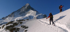


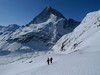


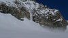


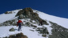


Mont Durand, also known as the Arbenhorn, is a great panoramic point. Matterhorn on one side, Dent Blanche on the other. From the Schönbielhütte an early morning descent on the edge of the moraine to the plateau Hohle Bielen. On a sunny day it is necessary to overcome the steep slope below the Schönbielhorn in good time. More precisely above the edge of the Hohwäng glacier up to an altitude of 3200 m. Continue with a slight ascent along this glacier in a northeastern direction above the level of the Col Durand saddle. Until the height to which it is possible to climb on skis and with crampons and ice ax on a relatively exposed slope to the summit. If you follow the ascent route, watch out for avalanches and snow slides that come from the Schönbielhorn in the afternoon sun.
Peak
- Country
- Switzerland
- Montains
- Walliser Alpen / Alpes valaisannes
- Tags
- Alpes valaisannes Haute Route Imperial Schweiz Switzerland Tour du Ciel Valais Valais Alps Wallis Walliser Alpen Zermatt
- Hut
- Schönbielhütte
- UTM / CH1903 x ("longitude" E/W)
- 616411
- UTM / CH1903 y ("latitude" N/S)
- 98042
Start point
- Start Point
- Schönbielhütte
- Altitude
- 2694 m
- UTM / CH1903 x ("longitude" E/W)
- 614746
- UTM / CH1903 y ("latitude" N/S)
- 94503
Conditions
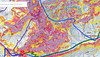
- Avalanche danger
- www.slf.ch
- Weather
- SRF Meteo Meteoschweiz Zermatt, snow-forecast.com Klein Matterhorn, meteoblue.com Wandfluehorn 3589 / mountain-forecast.com Tete Blanche 3750m / mountain-forecast.com Tete Valpelline 3798m / mountain-forecast.com Mont Durand, mountain-forecast.com Schweiz TV - animation Bergwetter / alpenverein.at Zermatt / kachelmannwetter.com Gornergrat 3130m / meteocentrale.ch
- Snow report
- Zermatt, snow-forecast.com Zermatt, bergfex.ch Zermatt, onthesnow.com Zermatt, skiresort.info snow.myswitzerland.com/
- Webcams
- Zermatt - Schwarzsee Zermatt - Bahnhof Zermatt - 29 webcams
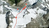
Ski tour map on Mont Durand / Arbenhorn


 bivakovací nouzová chata
  cepín a mačky potřeba
 exponovaný, obtížný terén
 horská chata
 hôtel, penzion
 lanovka, vlek
 lavinové nebezpečí, svah > 30°
 ledovcové trhliny
 lehká túra
 mimořádně obtížná túra
 mírně obtížná túra
 obtížná túra
 parkoviště
 přístup k chatě
 restaurace
 sedlo
sedlo sjezd
sjezd skidepo
 vrchol
 výstup
 začátek ledovce
- bivouac, winter room
- crampons & ice axe necessary
- exposed, difficulty terrain
- mountain hut, refuge
- hotel, pension
- cableway, skilift
- avalanche danger, slope > 30°
- glacier cracks
- little difficult tour
- extremely difficult tour
- rather difficult tour
- difficult tour
- parking
- hut acces
- restaurant
- col, pass, saddle
- descent
- skidepot
- peak, summit
- ascent
- glacier beginning
- biwak, winterraum
- steigeisen & pickel erforderlich
- ausgesetzt, schwierige gelände
- berghütte
- hotel, pension
- seilbahn, skilift
- lawinengefahr, hangneigung > 30°
- gletscherspalten
- wenig schwierige tour
- äusserst schwierige tour
- ziemlich schwierige tour
- schwierige tour
- parkplatz
- zugang zur hütte
- restaurant
- sattel, joch, pass
- abfahrt
- skidepot
- gipfel
- aufsieg
- gletscher anfang
- bivacco, locale invernale
- ramponi & piccozza necessari
- esposto, terreno difficolt?
- rifugio, capanna
- alberghi, pensione
- funivia, seggiovia
- pericolo di valanghe, pendenza > 30°
- crepe glacier
- tour piccolo difficile
- tour estremamente difficile
- tour piuttosto difficile
- escursioni difficili
- parcheggio
- accesso capanna
- ristorante
- col, sella, passo, forcella
- discesa
- sci deposito
- picco, vertice, piz
- salita
- inizio ghiacciaio
- bivouac, local d'hiver
- crampons & piolet nécessaire
- exposée, difficulté du terrain
- cabane de montagne, refuge
- hôtel, pension
- téléphérique, téléski
- danger d'avalanche, pente > 30°
- crevasse du glacier
- peu difficile tour
- extr?mement difficile tournée
- assez difficile tour
- difficile tournée
- parking
- acces cabane
- restaurant
- col, selle
- descente
- skis dépôt
- pic, sommet
- ascension
- début glacier
- < 20°
- 20° - 25°
- 25° - 30°
- 30° - 35°
- 35° - 40°
- > 40°
Current weather conditions in the tour area
Planning of ski tour
- Fitness difficulty
-
- ♦♦♦◊
- Technical difficulty
-
- ♦♦♦◊
- best time for this tour
- Glacier
- Yes
- Map
- Arolla 283 S, Swisstopo 1:50000 Matterhorn 1347, Swisstopo 1:25000 Zermatt 1348, Swisstopo 1:25000
- Guides
- Ski de randonnée Bas-Valais Die klassischen Skitouren (SAC, deutsch) Les classiques de randonnée à ski (SAC, francais) Walliser Alpen (Rother, deutsch)
About Ski tour
- Time difficulty
- Ascent (height difference)
- 1630 m
- Lenght of ascent
- 5,5 km
- Descent (height difference)
- 1630 m
- Total Lenght of tour
- 7 km
- Total time of the tour
- 7-10 h
- Elevation Range
- 2430 - 3713 m
- Principal Aspect
- E, SE, S, SW S-south, N-north, W-west, E-east
Download
- GPX (track only)
- Mont-Durand_SchoenbielH_TRK.gpx best for display on a detailed topographical map (mapy.cz) or in apps for smartphones (Locus, Garmin Connect, etc.)
- GPX (waipoints, track)
- Mont-Durand_Schönbiel-Hut_skitour.gpx great for uploading in GPS device
- KML (with POI)
- MontDurand_SchonbielHut_skitour Guru.kml for viewing in the Google Earth 3D map application, which you can install on your PC
Video of tour on Mont Durand / Arbenhorn
tour Mont Durand / Arbenhorn - Reviews
There are no reviews in this section yet. Click the Add Review button to add first review.
Ski tours around Hut Schönbielhütte, in mountains Walliser Alpen / Alpes valaisannes, Switzerland
-

Tour du Ciel - day 2 3404 m
Schönbielhütte Walliser Alpen / Alpes valaisannes Switzerland
- Length of ascent5 km
- ascent1190 m
- duration5-7 h
- Fitness difficulty ♦♦♦◊
- Technical difficulty ♦♦♦◊
Tour du Ciel (known as the reverse direction of the Haute Route Impériale) begins with the first real stage from the Schönbiel Hut, featuring a descent along the edge of the moraine. This is followed by a long, steep climb over glacier seracs, ideally tackled in the early morning. The subsequent ascent over the Hohlwäng Glacier to the Col Durand (3404 m) is then straightforward. An alternative is to turn right before the pass and climb Mont Durand. From the pass, descend over the Glacier Durand, followed by a short climb to the Cabane Mountet.

-

Tour du Ciel - day 1 2695 m
Schönbielhütte Walliser Alpen / Alpes valaisannes Switzerland
- Length of ascent6,5 km
- ascent650 m
- duration4-5,5 h
- Fitness difficulty ♦♦♦◊
- Technical difficulty ♦♦◊◊
The high-altitude crossing Tour du Ciel begins in Zermatt and ends in the Val d’Anniviers, running from north to south. The first stage starts in Zermatt; for better acclimatization, it is recommended to spend the night at the Schönbiel Hut – possibly combined with an ascent of the Tête Blanche. The easiest version of the route begins at the upper station of the Schwarzsee cable car.
Best ski tours in Walliser Alpen / Alpes valaisannes by skitour.guru
-

Breithorn - Zermatt 4164 m
Monte Rosa Hütte Walliser Alpen / Alpes valaisannes Switzerland
- Length of ascent3 km
- ascent440 m
- duration3-4 h
- Fitness difficulty ♦♦♦◊
- Technical difficulty ♦♦♦◊
Breithorn can be rated as the lightest 4000 in the Alps. In any case, thanks to the support of the Klein Matterhorn cable car, which transports ski mountaineers up to 3880 m. From the cable car station (beautiful viewpoint) to the glacier plain below the summit, which can be often reached on skis. In good conditions, it is worthwhile to continue to the Schwarztor saddle and drive descent back to Zermatt. The second variant of the freeride is the descent from the Unterer Theodulgletscher. This descent is simply great up to Seehöre 2400.
-

Tour du Ciel - day 5 3030 m
Turtmannhütte / Cabane Tourtemagne Walliser Alpen / Alpes valaisannes Switzerland
- Length of ascent5,5 km
- ascent1110 m
- duration5-7 h
- Fitness difficulty ♦♦◊◊
- Technical difficulty ♦♦◊◊
A relatively easy ascent, though steep in places, from Lake Turtmannsee, which is reached by descending from the Turtmannhütte. From the summit ridge, there's a long descent to the Hotel Weisshorn, followed by forest trails leading down to the village of St. Luc - Chandolin in the Val d'Anniviers.
-

Blanc de Moming - Dôme Circuit 3649 m
Cabane du Mountet Walliser Alpen / Alpes valaisannes Switzerland
- Length of ascent10 km
- ascent2035 m
- duration9-11 h
- Fitness difficulty ♦♦♦♦
- Technical difficulty ♦♦♦♦
Blanc de Moming - Dôme is a beautiful but also very demanding complex ski tour. First ascent from Cabane Mountet to La Forcle saddle and then not very easy descent and then ascent along the Glacier du Besso. At the end of the glacier there is an uncomfortable border between snow and rock. Climb a rocky slope. First along a flat ridge, which is increasingly exposed. It is recommended to belay in windy weather. At the beginning of the spectacular descent along the Glacier de Moming, pay attention to the gigantic cracks. The departure line (keep left) turns from the northern to the western slope. After reaching the valley there is an easy ascent along the Glacier de Zinal back to Cabane Mountet.