
 Česky
Česky Deutsch


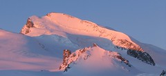
Variant of the Haute Route Gran Lui from Chamonix to Zermatt: From the Cabane du Trient hut over the Col de Plines pass and descent onto the Glacier de Saleinaz. This is followed by an ascent to the Col de la Grande Lui pass. From the pass, a long descent leads to the mountain village of La Fouly.
Peak
- Country
- Switzerland
- Montains
- Walliser Alpen / Alpes valaisannes
- Tags
- Argentiére Cabane Trient Haute Route Haute Route Grande Lui Haute Route Chamonix-Zermatt La Fouly
- Hut
- Cabane Trient
- Other Huts
- La Fouly
- UTM / CH1903 x ("longitude" E/W)
- 569911
- UTM / CH1903 y ("latitude" N/S)
- 89652
Start point
- Start Point
- Cabane Trient
- Altitude
- 3170 m
- UTM / CH1903 x ("longitude" E/W)
- 569402
- UTM / CH1903 y ("latitude" N/S)
- 94304
Conditions
- Avalanche danger
- www.slf.ch
- Weather
- Cabane Trient, meteoblue.com Petite Pointe d´Orny 3187m / mountain-forecast.com Aig. du Pissoir 3440m / mountain-forecast.com Pointe des Grandes 3101m / mountain-forecast.com Tete de Balme 2321m / mountain-forecast.com La Breya 2194m / mountain-forecast.com Le Tour, meteoblue Grands Montets, meteoblue.com Lac Champex, meteoblue Meteoschweiz Vallorcine-Le Tour
- Snow report
- Champex-Lac, bergfex.ch Verbier,skiresort.info Le Tour, snow-forecast.com Chamonix, onthesnow.com
- Webcams
- Lognan - Grands Montets Les Autannes Trient Glacier Chamonix, all webcams Champex - Val Arpette
Ski tour map on Col Grande Lui - H.R. Grande Lui, Day 2


 bivakovací nouzová chata
  cepín a mačky potřeba
 exponovaný, obtížný terén
 horská chata
 hôtel, penzion
 lanovka, vlek
 lavinové nebezpečí, svah > 30°
 ledovcové trhliny
 lehká túra
 mimořádně obtížná túra
 mírně obtížná túra
 obtížná túra
 parkoviště
 přístup k chatě
 restaurace
 sedlo
sedlo sjezd
sjezd skidepo
 vrchol
 výstup
 začátek ledovce
- bivouac, winter room
- crampons & ice axe necessary
- exposed, difficulty terrain
- mountain hut, refuge
- hotel, pension
- cableway, skilift
- avalanche danger, slope > 30°
- glacier cracks
- little difficult tour
- extremely difficult tour
- rather difficult tour
- difficult tour
- parking
- hut acces
- restaurant
- col, pass, saddle
- descent
- skidepot
- peak, summit
- ascent
- glacier beginning
- biwak, winterraum
- steigeisen & pickel erforderlich
- ausgesetzt, schwierige gelände
- berghütte
- hotel, pension
- seilbahn, skilift
- lawinengefahr, hangneigung > 30°
- gletscherspalten
- wenig schwierige tour
- äusserst schwierige tour
- ziemlich schwierige tour
- schwierige tour
- parkplatz
- zugang zur hütte
- restaurant
- sattel, joch, pass
- abfahrt
- skidepot
- gipfel
- aufsieg
- gletscher anfang
- bivacco, locale invernale
- ramponi & piccozza necessari
- esposto, terreno difficolt?
- rifugio, capanna
- alberghi, pensione
- funivia, seggiovia
- pericolo di valanghe, pendenza > 30°
- crepe glacier
- tour piccolo difficile
- tour estremamente difficile
- tour piuttosto difficile
- escursioni difficili
- parcheggio
- accesso capanna
- ristorante
- col, sella, passo, forcella
- discesa
- sci deposito
- picco, vertice, piz
- salita
- inizio ghiacciaio
- bivouac, local d'hiver
- crampons & piolet nécessaire
- exposée, difficulté du terrain
- cabane de montagne, refuge
- hôtel, pension
- téléphérique, téléski
- danger d'avalanche, pente > 30°
- crevasse du glacier
- peu difficile tour
- extr?mement difficile tournée
- assez difficile tour
- difficile tournée
- parking
- acces cabane
- restaurant
- col, selle
- descente
- skis dépôt
- pic, sommet
- ascension
- début glacier
- < 20°
- 20° - 25°
- 25° - 30°
- 30° - 35°
- 35° - 40°
- > 40°
Current weather conditions in the tour area
Planning of ski tour
- Fitness difficulty
-
- ♦♦♦◊
- Technical difficulty
-
- ♦♦♦◊
- best time for this tour
- March-April
- Glacier
- Yes
- Map
- Martigny 282 S, Swisstopo 1:50000 Barberine 1324, Swisstopo 1:25000 Col de Balme 1344, Swisstopo 1:25000 Orsières 1345, Swisstopo 1:25000 Chamonix 3630, IGN 1:25000
- Guides
- Ski de randonnée Bas-Valais Die klassischen Skitouren (SAC, deutsch) Les classiques de randonnée à ski (SAC, francais) Walliser Alpen (Rother, deutsch) Haute Route (Rother, deutsch) Haute Route Chamonix-Zermatt (JM editions, french)
About Ski tour
- Time difficulty
- Ascent (height difference)
- 925 m
- Lenght of ascent
- 6 km
- Descent (height difference)
- 2500 m
- Total Lenght of tour
- 13,5 km
- Total time of the tour
- 6-8 h
- Elevation Range
- 1600 - 3416 m
- Principal Aspect
- S, N S-south, N-north, W-west, E-east
Download
- GPX (track only)
- HR_CabTrient-LaFouly_TRK.gpx best for display on a detailed topographical map (mapy.cz) or in apps for smartphones (Locus, Garmin Connect, etc.)
- GPX (waipoints, track)
- HR GranLui_Trient-LaFouly_skitour.gpx great for uploading in GPS device
- KML (with POI)
- HR_TrientCab-GrLuy-LaFouly.kml for viewing in the Google Earth 3D map application, which you can install on your PC
Current avalanche potential on tour - Col Grande Lui - H.R. Grande Lui, Day 2

tour Col Grande Lui - H.R. Grande Lui, Day 2 - Reviews
There are no reviews in this section yet. Click the Add Review button to add first review.
Ski tours around Hut Cabane Trient, in mountains Walliser Alpen / Alpes valaisannes, Switzerland

Best ski tours in Walliser Alpen / Alpes valaisannes by skitour.guru
-
Strahlhorn 4190 m
Britannia Hütte Walliser Alpen / Alpes valaisannes Switzerland
- Length of ascent9,4 km
- ascent1250 m
- duration6-8 h
- Fitness difficulty ♦♦♦◊
- Technical difficulty ♦♦◊◊
Strahlhorn (Britannia Hütte, Walliser Alpen) is a classic glacier ski tour from Britannia Hütte. From the Adlerpass saddle, you usually go skiing to the top. To get off Saas Fee, take the Metro to the "window" at 3460 m to the Hohlaub Gletscher and start the ascent after a short ride.

-

La Luette 3547 m
Cabane des Dix Walliser Alpen / Alpes valaisannes Switzerland
- Length of ascent3 km
- ascent710 m
- duration1,5-3 h
- Fitness difficulty ♦♦◊◊
- Technical difficulty ♦♦◊◊
La Luette je vděčná túra z chaty Cabane Dix. Po mírném svahu na ledovec Glacier de la Luette a v závěru po hřebenu na vrchol. Pouhých 500 výškových metrů od chaty může být lákadlem pro odpolední túru poté, když dorazíte brzo na chatu Dix.
-

Col Valpelline, Day 6 H.R. Chamonix-Zermatt 3551 m
Cabane des Vignettes Walliser Alpen / Alpes valaisannes Switzerland
- Length of ascent9 km
- ascent1485 m
- duration8-10 h
- Fitness difficulty ♦♦♦◊
- Technical difficulty ♦♦♦◊
The last stage of the Haute Route Chamonix - Zermatt is an ode to skiing. After an easy ascent to three saddles - Col de Eveque, Col du Mont Brulé and Col Valpelline. Every ski mountaineer will be amazed by the panorama of the impressive 4000m peaks - Dent Blanche, Matterhorn and Dent d´Hérens. This is followed by a 10 km descent to Zermatt.